DAY ONE
War, innovation, tragedy and political intrigue have each logged visits to Sumter County over the years. The county’s history is rich and adventurous, and it seems every nook and cranny has a story to tell.
Start the day at the Dade Battlefield Historic State Park. The park itself opens at 8 AM and the welcome center opens at 9 AM. From I-75, take Exit 314 and head east on County Road 48. In about a mile, turn south onto County Road 603. The park is a mile down on the right.  You can walk the route Major Dade and his men took in 1835 when they were attacked by Seminole warriors. The battle started the 2nd Seminole War. There is also plenty of wildlife to see—everything from tortoises to hawks. The park offers picnic areas and public restrooms. On Saturdays, there are guided tours of the battlefield at 10 AM and 2 PM. Every January, the park hosts a battle reenactment and festival.
After the Dade Massacre, the Army sent Major Robert Armstrong and a group of soldiers to build a fort near the site of the battle. Though the fort is gone, a registered historical marker marks the spot on which the fort stood. Head back north on 603 for a quarter mile and turn left onto County Road 476. The marker is about 150 yards on the right, just as a pond comes into view. There is a place to park and the marker makes a great place for a family photo.
A few days after the Army finished construction on Ft. Armstrong, Major General Keith Call, the territory governor who had been politically appointed to command the army troops in Florida, sallied from Ft. Armstrong to attack the Seminoles. The Native Americans were caught off guard and the battle should have been a rout. However, the poorly led American force stalled, and their subsequent defeat ultimately proved to be the war’s turning point. Continue west on 476 until you cross over I-75. Immediately after the overpass, turn right onto County Road 616 and head north for less than a mile and turn left onto 48. Continue west for about 5 miles.  The Wahoo Community Building is on the right. A marker commemorates the battle and there are picnic facilities and restrooms. It’s the perfect place to stop for lunch and to toss the Frisbee around for a while.
One of the few American standouts in the Battle of Wahoo Swamp was Major David Moniac, the first Native American to graduate from West Point. He was killed leading his men across a small river during the battle. There is a memorial to him at the Florida National Cemetery, ten minutes south of the Wahoo marker. The cemetery is also the final resting place of thousands of American veterans, including two Medal of Honor winners. Take 48 back toward the interstate and turn right onto County Road 625 in 3.3 miles. Turn right (west) onto 476 and then left onto County Road 476B in a mile and a half. The cemetery is two and a half miles on the right.
To quote the most famous war drama in history, tomorrow is another day. It’s time to head back to Bushnell for dinner and maybe a movie, then find one of the city’s great hotels and catch a good night’s sleep.
DAY TWO
Start the day by heading about fifteen minutes north of Bushnell to Adamsville, the original county seat of Sumter County. Take US 301 north for about twelve miles, including the right-hand turn in Coleman. A little over a mile after you turn, you will turn right again onto Warm Springs Ave. 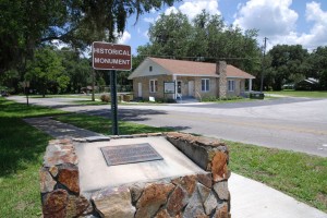 The marker is on the right, just in front of Adamsville Baptist Church. Along the way, there are numerous local places to get some breakfast, including the Fenney Grill, plus many small shops and roadside fruit stands, and plenty of rural Florida scenery.
Adamsville was named the county seat in 1853. By 1881, the seat had moved three times. In October of that year, the citizens of Sumter County voted that Sumterville be named the new county seat. After two years of infighting and legal wrangling, the state legislature finally recognized the election and construction began on a new courthouse. Less than twenty years later, the courthouse burned to the ground and it took another three years of political machinations and backbiting before the voters chose Bushnell as the new-and-final county seat by a razor thin margin. Get back to 301 and take it toward Bushnell for 5.2 miles. The marker for the old courthouse is on the left, just outside the Sumterville Community Building. There is a playground for the kids and a picnic area for lunch.